


MyRadar
News
—
The Fascinating Science behind Fire Clouds
by Colin McCarthy | News Contributor
7/14/2022
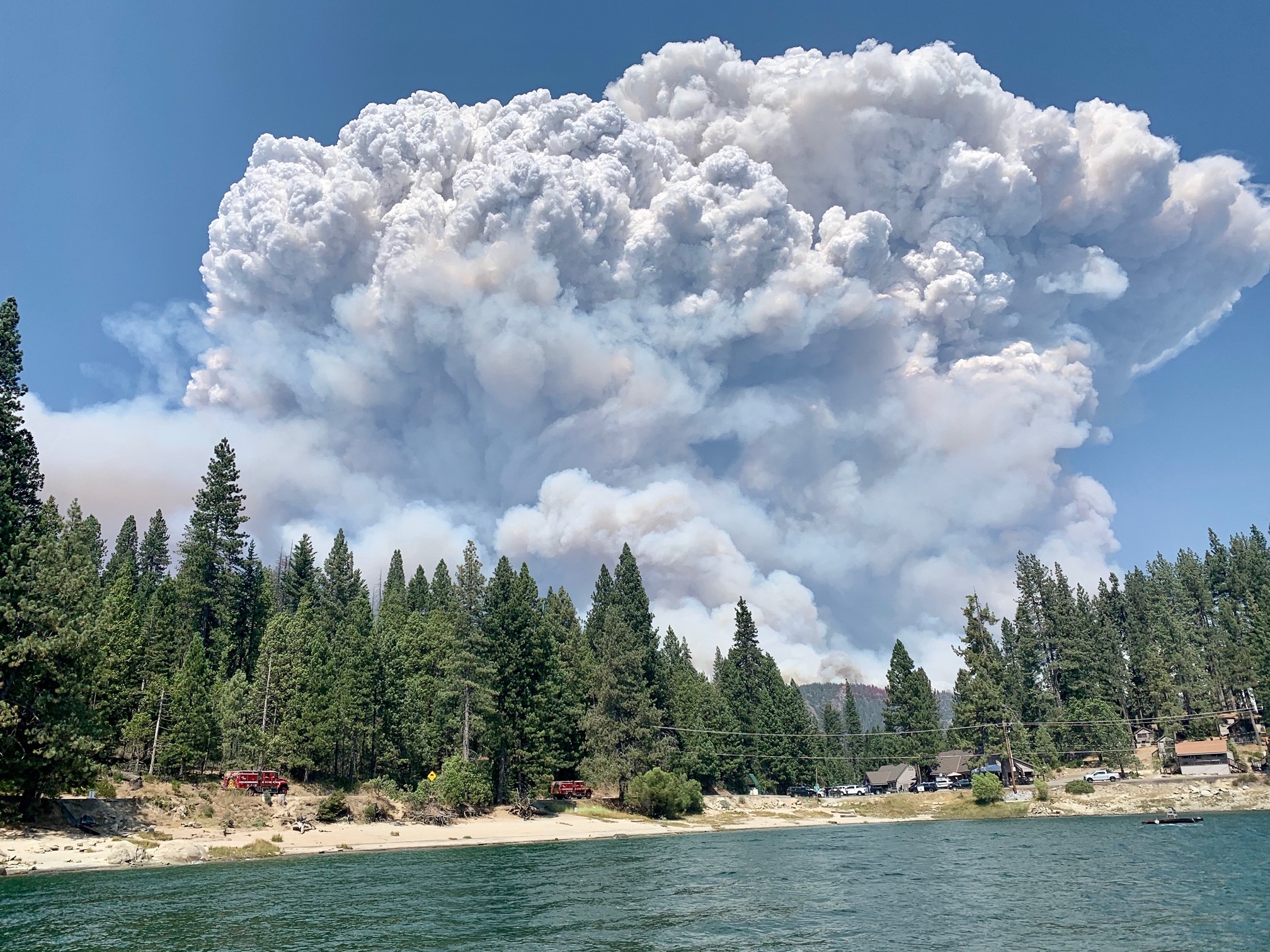
Pyrocumulus clouds, also known as fire clouds are one of the most dangerous, yet fascinating forms of extreme fire behavior that only occur in the most intense wildfires. Pyrocumulus clouds are one of the ways wildfires can create their own weather and can even lead to the formation of fire whirls or even fire tornadoes.
An enormous fire whirl was just visible moments ago on the #DixieFire with very extreme fire behavior ongoing on the fire. #CAwx #CAfire pic.twitter.com/SscXcsD6dW
— US StormWatch (@US_Stormwatch) August 10, 2021
Pyrocumulus clouds form when wildfires superheat the air at the surface which then begins to rise into the atmosphere. This hot and buoyant air ascends into the cooler atmosphere above carrying water vapor, smoke, and ash before it condenses into a cumulus cloud.
Most wildfires do not burn hot enough to produce pyrocumulus clouds, but when extremely hot fires burn in a hot and unstable atmosphere, pyrocumulus clouds can mature into even more dangerous pyrocumulonimbus clouds. These pyrocumulonimbus clouds can reach as high as 40,000-50,000 feet in the air, above the cruising altitudes of most commercial airplanes. One of the most classic examples of a pyrocumulonimbus cloud was witnessed on the Creek Fire in September 2020 which produced a mammoth fire cloud up to 50,000 feet tall, visible from hundreds of miles away.
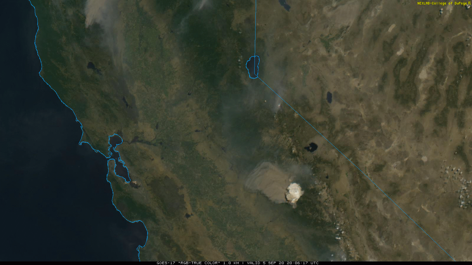
The Creek Fire in 2020 producing a pyrocumulonimbus cloud topping at 50,000 feet. Image Credit: GOES-17 Satellite, National Weather Service
Pyrocumulonimbus clouds bring a whole new level to wildfires creating their own weather. While pyrocumulus clouds can create brief fire whirls and even weak fire tornadoes, pyrocumulonimbus clouds can become full-fledged supercell thunderstorms with the potential to produce strong, borderline violent tornadoes. The most extreme example of this was seen with the Carr Fire in California in 2018. On July 26 the Carr Fire produced a long-duration EF3 fire tornado with winds over 140 mph that stayed on the ground for 30 minutes.
The tornado caused severe damage, completely debarking trees, mangling high tension powerlines, and even causing ground scouring which is typically only observed in violent (EF4+) tornadoes. The tornado impacted residential areas of Redding, CA and tragically 3 people were killed as the fire tornado's winds caused their home's walls to blow out which resulted in the roof collapsing.
The NWS & @CAL_FIRE Serious Accident Review Team (SART) are conducting a storm damage survey regarding the large fire whirl that occurred Thursday evening in Redding. Preliminary indicators placed max wind speeds achieved by the fire whirl in excess of 143 mph. #cawx #CarrFire pic.twitter.com/3iRX90lhLJ
— NWS Sacramento (@NWSSacramento) August 2, 2018
Fire clouds can also help create full-fledged thunderstorm outbreaks completely by themselves. This was most incredibly witnessed last June and July during the historic 1-in-1000-year Pacific Northwest heatwave. Dozens of rapidly spreading wildfires were sparked across British Columbia which began producing pyrocumulonimbus clouds which generated one of the most incredible fire-generated lightning outbreaks ever observed. Over 700,000 lightning strikes were produced by the fire-generated clouds in one night which then sparked dozens of new fires. Essentially this caused a self-perpetuating outbreak of wildfire across British Columbia as wildfires generated new wildfires through the lightning strikes produced from their pyrocumulonimbus plumes. Truly mind-boggling stuff.
One of the most insane pyroconvective events witnessed during the satellite era is currently occurring across British Columbia.
— US StormWatch (@US_Stormwatch) July 1, 2021
The Sparks Lake Wildfire and McKay Creek Wildfire are producing fire-generated severe thunderstorms resulting in frequent lightning and strong winds. pic.twitter.com/WuBnikXH63
With severe drought already gripping much of the West, expect to see an increasing number of fire clouds looming above wildfires later this summer and fall as wildfires burn hotter, larger, and more frequently than ever before.