


MyRadar
News
—
Severe Weather's Different Form in the Northeast
by Will Cano | News Contributor
7/18/2022
Everyone seems to know the tornado capital of the United States: Tornado Alley in the central Great Plains.
But this obviously isn't the only place that tornadoes occur.
Dixie Alley in the southeast is now the nation's capital for nighttime tornadoes. Hoosier Alley encompasses the path of the infamous Tri-State Tornado in 1925 — the longest-track tornado in history. Even Carolina Alley signifies a hotspot of tornadic activity historically seen across both Carolinas.
Yet even these aforementioned regions do not nearly encompass all tornadic regions in the U.S.
Each and every state experiences severe weather, and respectively, tornadic activity. One region, however, has seen an uptick in severe weather over the past two seasons and some meteorologists believe it is slated to continue.
The Northeast's severe weather season is just reaching its annual height.
The peak time for thunderstorm activity across the Northeast stretches from June to September. For many regions, the more specific peak falls between June 30th and July 20th.
Median date for peak of thunderstorm season. #climate pic.twitter.com/zzRYMHNAPp
— Brian Brettschneider (@Climatologist49) July 11, 2016
Notably, this timeframe falls in the summer, and for a justifiable reason. It is because of the fundamental ingredients necessary for thunderstorms to form: moisture, warmth, and lift.
In the summer, warmth is easy to find across the Northeast. Average temperatures are in the 80s and the 90s are nowhere near uncommon. This warmth is important for thunderstorms because it helps to create lift in the atmosphere. That process, coupled with abundant moisture (also a Northeast normality) creates billowing Cumulonimbus clouds.
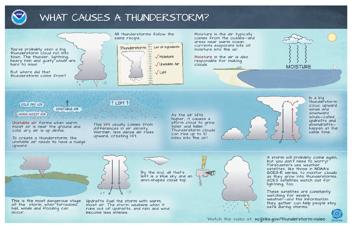
The process of thunderstorms forming, sustaining, and losing strength is a careful balance of warm air and moisture, as displayed above. Image Credit: NOAA SciJinks
As thunderstorm activity becomes more common in the summer across the Northeast, there become more opportunities for severe weather. For this reason, the Northeast's severe weather season falls in the summer rather than the spring, unlike tornado hotspots across the Central U.S.
This has been seen in epic proportions in the past. One example is the historic derecho on June 29, 2012. Derechos are strong lines of thunderstorms that have a bow-like shape as they move. This bow causes strong wind speeds in excess of 58 mph over long distances. In some cases, these winds can exceed 80 mph.
Between June 29th and 30th, 2012, a line of severe thunderstorms traveled 850 miles from Iowa to the Mid-Atlantic. It grew in size as it marched along, and at its peak stretched from New Jersey to the Outer Banks. The storm hit multiple major cities, caused 5 million power outages, and even produced a 91 mph wind gust in Indiana. It was responsible for a total 22 deaths when it finally dissipated.
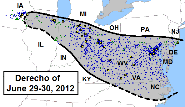
A diagram and animation showing the scope of the 2012 Derecho that struck the Ohio River Valley and the mid-Atlantic. It was one of the first times the term "Derecho" became a widely known weather phenomena. The diagram depicts all reports of severe weather, while the animation shows a loop of the radar imagery. Image Credit: Storm Prediction Center
Another example of a summer Derecho came on June 3, 2020. It struck the Philadelphia region with 80 mph wind gusts, with a maximum wind gust of 93 mph in New Jersey. Later in the evening, a second storm system (this time, a supercell thunderstorm) rolled through, prompting a tornado warning in Philadelphia. The one-two punch caused power outages that lasted one week in some spots.
While a tornado never touched down from this storm, it was an eerie reminder that the summer is the most likely time for a tornado to strike the Northeast.
This strongly resonates when thinking of the June 9th, 1953 tornado in Worcester, Massachusetts. Given an F-4 rating, the storm is known as the worst tornado to ever strike the northeastern U.S. It's destructive 35-mile path caused extreme damage nearly worthy of an F-5 rating. A total of 93 people died, and over 1,200 were injured.
The tornado lasted 84 minutes, tossed debris as far as Cape Cod, and took homes from 5% of the Worcester population.
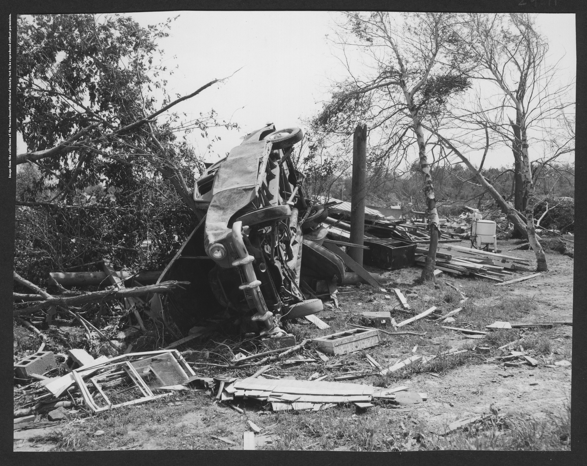
Heavy damage to a car on June 10th, 1953 caused by the Worcester, Massachusetts tornado. Image Credit: Massachusetts Historical Society
Another example of a strong summertime tornado comes from southeastern Pennsylvania, where an F-4 tornado destroyed a housing complex near Limerick on July 27, 1995. It was the strongest tornado the area has ever seen to date and still remains in the memory of many local residents.
The Northeast also gets its fair share of severe weather and tornadoes due a different factor: the tropics. When strong tropical storms make landfall along the Gulf or East Coast, prevailing winds frequently steer the storm's remnants towards the Mid-Atlantic and Northeast.
As this occurs, moisture is still associated with strong low-level circulation, and a plethora of rotating thunderstorms are born.
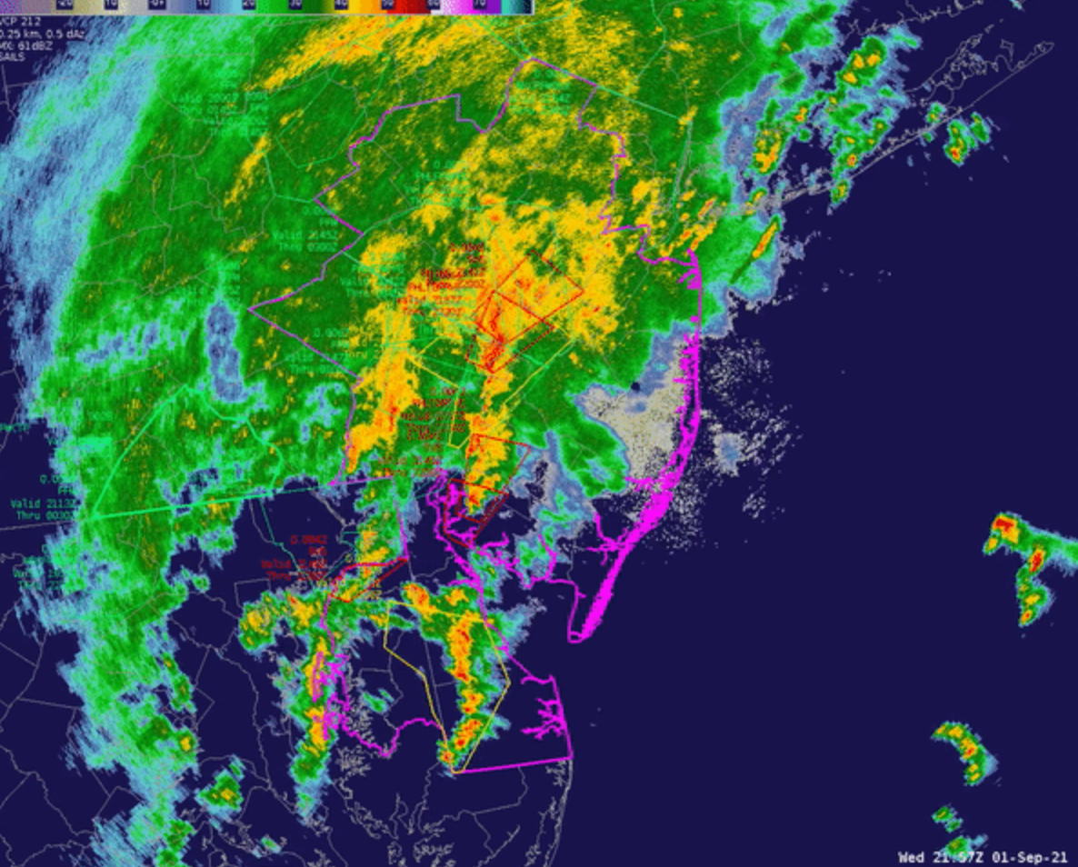
Take Hurricane Ida for an example. On September 1, 2021, the remnants of once-Category 4 Ida came into the Northeast causing unprecedented flooding. The storm also spawned a total of 21 tornadoes, 13 of which occurred in the Northeast, as did the only EF-3s and EF-2s.
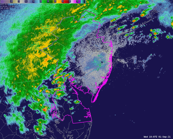
Compiled radar imagery of Hurricane Ida across the DC-Philly-NYC region as it produced heavy rain, thunderstorms, and tornadoes. Flash flood warnings are seen in green polygons, severe thunderstorm warnings are seen in yellow, and tornado warnings are seen in red. Image Credit: NWS Mt. Holly
Hurricane Isaias was another example of a tropical system that brought severe weather to the Northeast, spawning a total of 36 tornadoes from South Carolina to Connecticut. Tornado warnings extended all the way to Vermont. Similarly, Hurricane David spawned over a dozen tornadoes across the Mid-Atlantic in August 1979.
While thunderstorms, tornadoes, and tropical weather all highlight the violent weather the Northeast receives in the summer, this timeframe should be taken with a grain of salt. It is not the only time severe weather is possible in the region.
The volatile temperatures and weather patterns of spring often cause their own risk. Only two "moderate risk" days, the 2nd highest tier of severe weather forecasting from the Storm Prediction Center, have been observed in the Northeast. They both came in the month of May.
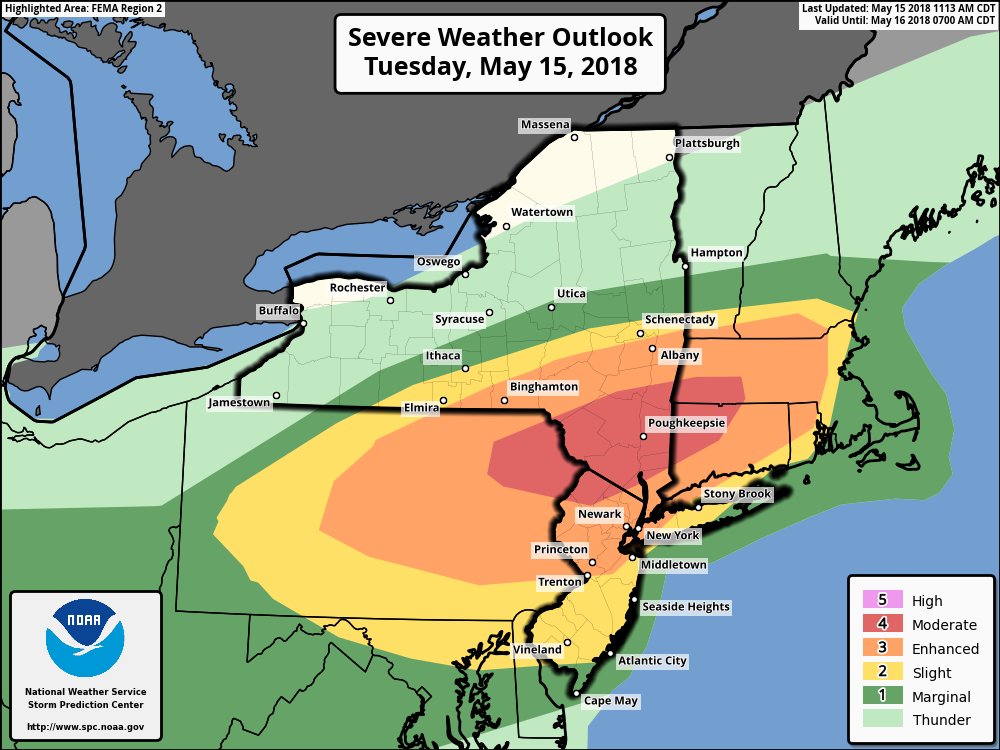
The Storm Prediction Center's outlook for severe weather on May 15th, 2018. This is one of only two times the Northeast has received a "moderate" outlook from the SPC's new rating system. Neither of them fell in the summer. Image Credit: NOAA Storm Prediction Center
As a result of the same science, the fall also produces chances for thunderstorm and tornadic activity. On November 13, 2021, 9 tornadoes touched down across the New York City area and surrounding suburbs.
Perhaps the oddest example of them all comes from Middlebury, Vermont. In 2021, an EF-1 tornado struck. This statement alone is shocking as tornadoes north of Massachusetts are a rarity. Even wilder, however, is this tornado occurred on March 26. The average March temperature for this region is a chilling 41°F — not the setting where a damaging tornado would be expected.
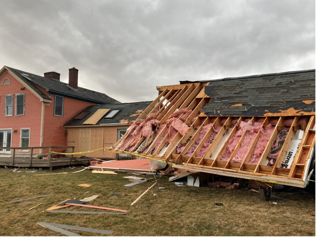
Damage in Middlebury, Vermont after an EF-1 tornado rolled through on March 26th, 2021. An in-depth discussion of this peculiarity can be seen here. Image Credit: NWS Burlington
The past two seasons in the Northeast have seen above average tornado counts with last year being an exceptional example in multiple regards. The year 2021 was the first year the National Weather Service in Mount Holly, Pennsylvania issued a "Particularly Dangerous Situation" for a tornado.
This came not only once but twice in the same number of months — one being an even-higher graded Tornado Emergency.
While both seasons were statistical anomalies, some studies have shown tornadic activity may be on the rise across the Northeast (most notably, "Spatial trends in United States tornado frequency" by NPJ Climate and Atmospheric Science).
It is unknown whether this increase may be due to natural trends or climate change as meteorologists have only kept track of tornado records since the 1970s. However, impacts of climate change on tornadic activity in the Unites States are certainly possible, as a warmer climate will affect the temperature, moisture, and instability of the atmosphere.
The Northeast is anything but immune from severe weather, and certainly proves that Tornado Alley is not the only place where a tornado can strike.