


MyRadar
News
—
Hurricane Season 2023: A Relief Compared to the Recent?
by Will Cano | News Contributor
5/30/2023
Yes, it's that time of year again.
The 2023 Hurricane Season is around the corner with its annual commencement on June 1st. With it comes four months — or longer — of prime conditions for the beasts of the Atlantic to form. Hurricane Ian most certainty met the qualifications of a 'beast' last year, with a devastating Category 4 landfall in late September.
Hurricane season officially lasts from June 1st to November 30th. Storms become much less frequent beginning in October, but this is not a hard deadline. Just look at last year's Hurricane Nicole, which made landfall on Florida's east coast on November 10th.
So, does this year have the potential to go on such a deep run, or to crank out a monster like Ian?
We may be in for a pleasant surprise, but nothing is guaranteed.

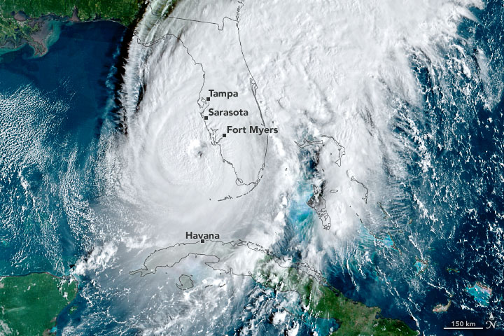
The menacing eye of Hurricane Ian approaching the Florida Gulf Coast on September 28th, 2022. The eye is so clear in the satellite imagery that the vibrant Gulf of Mexico can be seen, yet the dominant circulation of clouds is still evident. Nasa Earth Observatory
Many factors in our atmosphere influence where a hurricane forms, how strong it gets, and where it may go. Perhaps the most important are the ingredients needed to create a hurricane.
The first component is warm water. This makes sense: hurricane season falls in the summer and peaks in September — when the ocean temperatures across the Atlantic Ocean are at their warmest. Another component is moisture, which warm ocean water affects.
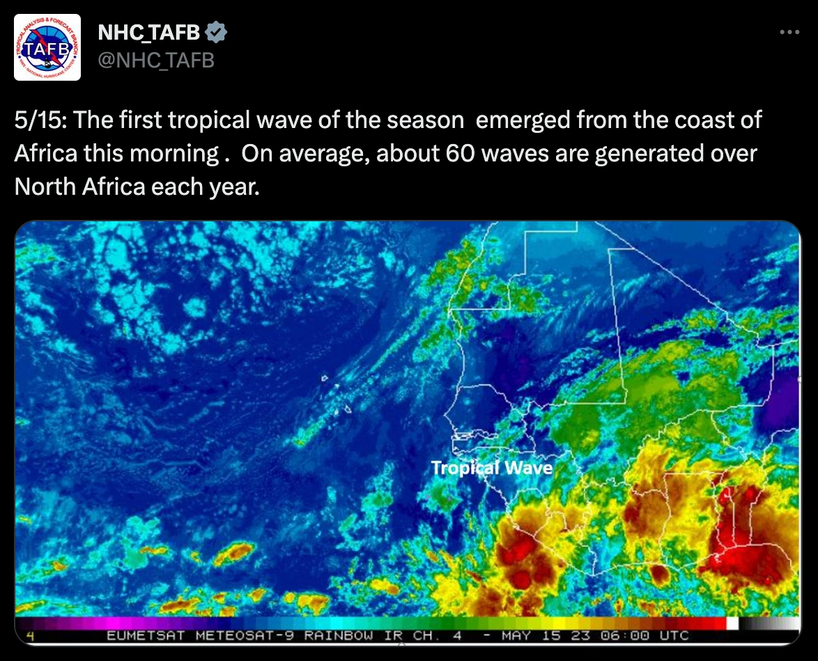
A 'jumpstart' of moisture is generally required to form a tropical system. This is most classically seen as collections of thunderstorms that travel west off the coast of Africa. These storms are known as 'tropical waves'.
Once a tropical wave moves over the Atlantic Ocean, it receives added moisture from the warm water that evaporates from the ocean's surface. With more moisture comes stronger thunderstorms, which creates a stronger low pressure system, strengthening the overall circulation. This cycle repeats itself until the wave progresses to a tropical depression, tropical storm, and ultimately a hurricane.
So why doesn't every thunderstorm over the Atlantic Ocean become a raging hurricane?
There are elements that can halt this progress or kill a hurricane in fast time. Quite predictably, one of these is dry air. Air in the atmosphere that has low humidity, or a low moisture content, can be swirled into a hurricane's circulation. This interferes with the warm, humid environment necessary for a hurricane to thrive. It can weaken a hurricane within hours.
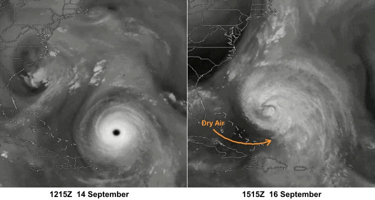
The difference that dry air can make in a matter of two days is clear. Here, Hurricane Isabel of 2003 weakened from a Category 5 storm to a Category 2 after dry air entered its circulation. Penn State College of Earth and Mineral Sciences
Another factor is wind shear, or how wind speed/direction changes with altitude. Interestingly, wind shear is one of the vital components when forming a tornado, but the opposite is true for a tropical storm. Wind shear pushes the heat and moisture away from the hurricane's center — the place where it intakes all energy. This same logic is true for the clouds of the hurricane as well. If the upper-level clouds are being moved in a different way than the lower-level clouds, the storm cannot keep a straight, vertical center and loses its stability.
An increase in wind shear over the Atlantic Basin is what may limit the number of hurricanes we see this season.
The summer of 2023 will have an oceanic anomaly known as El Niño. This is a pattern where warm ocean temperatures are seen at the equator compared to the historical average. The kicker? It occurs in the Pacific Ocean.
The El Niño is a phenomenon that generally occurs every two to seven years. It occurs complementary to La Niña — a phenomenon where below-average temperatures are seen across the Pacific Ocean's equator. The ocean has been in a La Niña state since the beginning of 2020, and just began to make its gradual switch to El Niño at the end of last year.
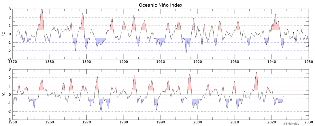
A graph representing the El Niño and La Niña patterns since 1870. The greater the amplitude, the stronger the given pattern was at the time. University of Miami
While the Pacific Ocean may seem too far away to matter to us, the opposite is true. The El Niño-La Niña relationship can affect winters, precipitation, temperature, and storm tracks seen across the United States. It also has a notable effect on hurricane season.
An El Niño pattern results in increased wind shear across the Atlantic Basin. This is caused by the downstream affects seen with the new oceanic heat it presents. It displaces the heat in the atmosphere, which greatly affects the atmospheric circulations seen around the globe. In the case of the Atlantic, a greater wind shear is the result, and a historically reduced risk of hurricanes.
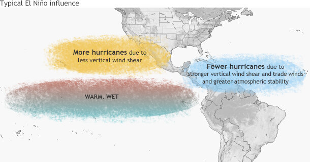
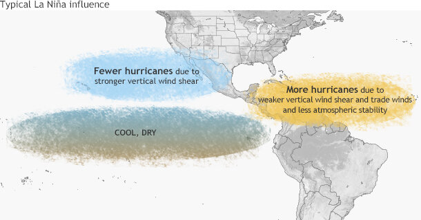
The different effects that the El Niño (left) and La Niña (right) patterns can have on hurricanes. Notice how each has the inverse effect on the Pacific Hurricane Season when compared to the Atlantic. NOAA Climate.gov
The last three seasons have all been near or above average (with a record-breaking 2020 above-average season), and La Niña is at least partly to blame. With El Niño in effect this summer, the hope is that this pattern will change. Colorado State University released its predictions for 2023 that include 13 named storms, six hurricanes, and two major hurricanes (all of which are one tally below average).
The National Oceanic and Atmospheric Administration (NOAA) will release its official forecast on May 25th (which can be found on https://www.noaa.gov/).
With all of this being said, the El Niño is just a pattern. It does not ensure a below average hurricane season, and any time that wind shear may let up temporarily is a dangerous window when the Atlantic can show what it is made of.
Until then, we'll appreciate this optimistic forecast.