


MyRadar
News
—
A Warm Christmas...With Big Changes To Follow?
by Will Cano | News Contributor
12/18/2023
Snow-lovers in the Northeast have seen a disappointing start to the '23 - '24 winter season.
Nearly the entire region has experienced above average temperatures and below average snowfall thus far (that is if you don't live in the ski towns of northern Vermont and New Hampshire, where Jay's Peak already has 115" of snow so far).
As a result, it's no surprise the National Weather Service's 6-10 Day Temperature Outlook was an unwelcome sight.
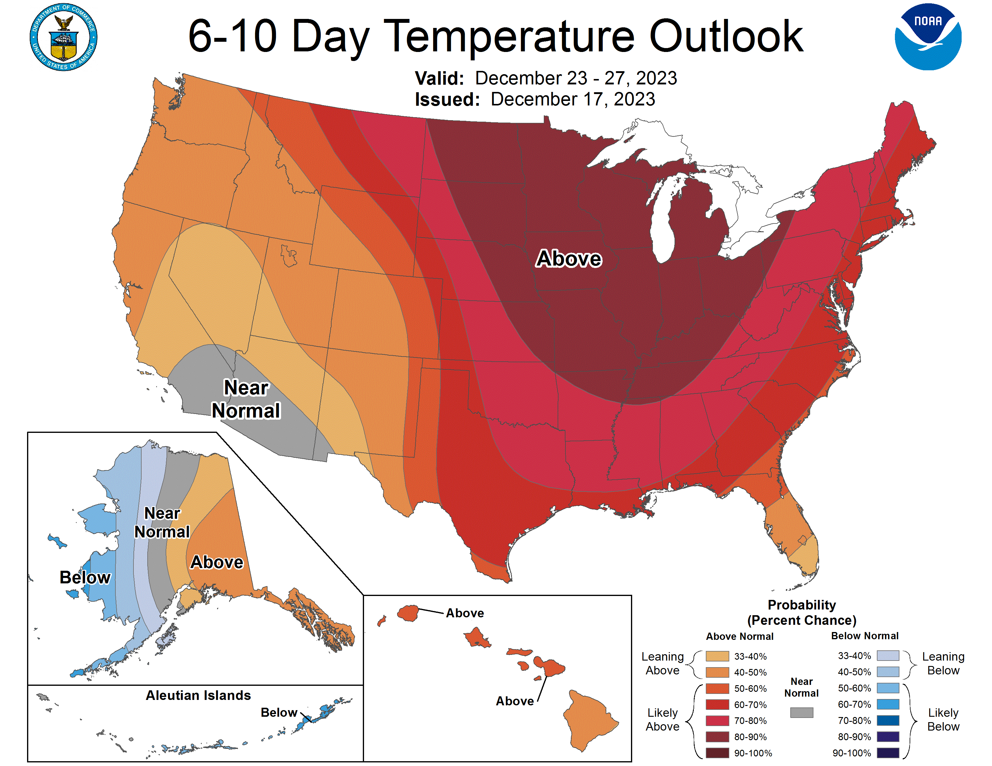
NWS Climate Prediction Center
This seems like a familiar story to many. Philadelphia recorded just 0.3" of snow last winter. Central Park has not received more than a coating since February 2022. Boston received 25% of their average annual snowfall last season.
Many seem quick to blame this year's strong El Niño on the warmth, which is when above average temperatures dominate the Pacific Ocean near the equator. However, studies show El Niño winters are not correlated with anonymously warm winters in the Northeast. There are a handful of other variables which have led to this year's warm start.
Luckily for winter enthusiasts, there are a handful of changes likely to occur that will shift the pattern heading into early January.
Let's break down the current driver of our weather: a Positive Eastern Pacific Oscillation (+EPO).
The EPO is simply a cycle over the eastern Pacific that brings warm or cold weather to the continental US based on its phase. A positive EPO is associated with warmth, and a negative EPO with cool. Its phase is dominated by two factors: the Pacific Jet Stream and the Aleutian Low.
A jet stream is a funnel of fast moving air concentrated at the 200 millibar level in our atmosphere (usually about 40,000 feet high). It is responsible for ridges and troughs across the continental US, where troughs are associated with cold air and ridges with warm air.
The Pacific is seeing what many are calling a 'Jet Extension', characterized by a persistent, flat jet stream extending from Asia all the way to California.
The Pacific Jet Stream has extended from Asia to the United States quite consistently this winter season, and is doing so in its strongest fashion now through Christmas. The result is strong ridging across the US and mild temperatures compared to average nationwide.
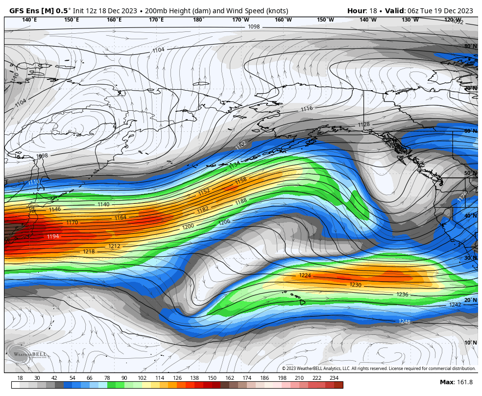
GFS Ensemble Model showing the consistent extension of the Pacific Jet Stream through Christmas and early January. This is one variable expected to change next month. WeatherBell
Once the new year rounds the corner, the strength and extent of this jet is expected to decrease. This is thanks to a few upstream changes, most importantly a wind shift over the Tibetan Plateau of China. The shift, called the East Asian Mountain Torque, cuts off the wind supply to the Pacific Jet.
The bottom line is the Pacific Jet stream is bringing lots of mild air to the US — much too mild to fuel major snowstorms.
The second piece of the EPO is the Aleutian Low, which is a low pressure system that exists over or near Alaska all winter long. Its position varies based on its strength. Currently, the low has a stronghold over the 49th State as it refuses to weaken. No ridging occurs over Alaska as a result, and zonal flow with mild temperatures dominate the continental 48 states.
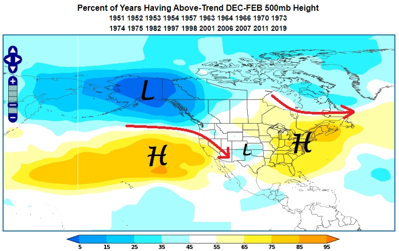
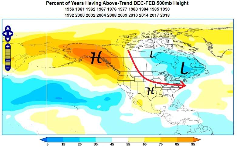
A +EPO is characterized by a strong low pressure over Alaska, leading to ridging and warmth across the Eastern US. World Climate Service
This pattern — with help from the Pacific Jet Extension — lead to the textbook +EPO seen above.
In the next two weeks, the Aleutian Low will weaken and gradually shift southward. This allows for warmer temperatures and ridging to replace the low over Alaska. The ridge completes the trifecta — it bends and weakens the Pacific Jet extension, allows for a trough to form over the lower 48, and lowers temperatures for us in the Northeast.
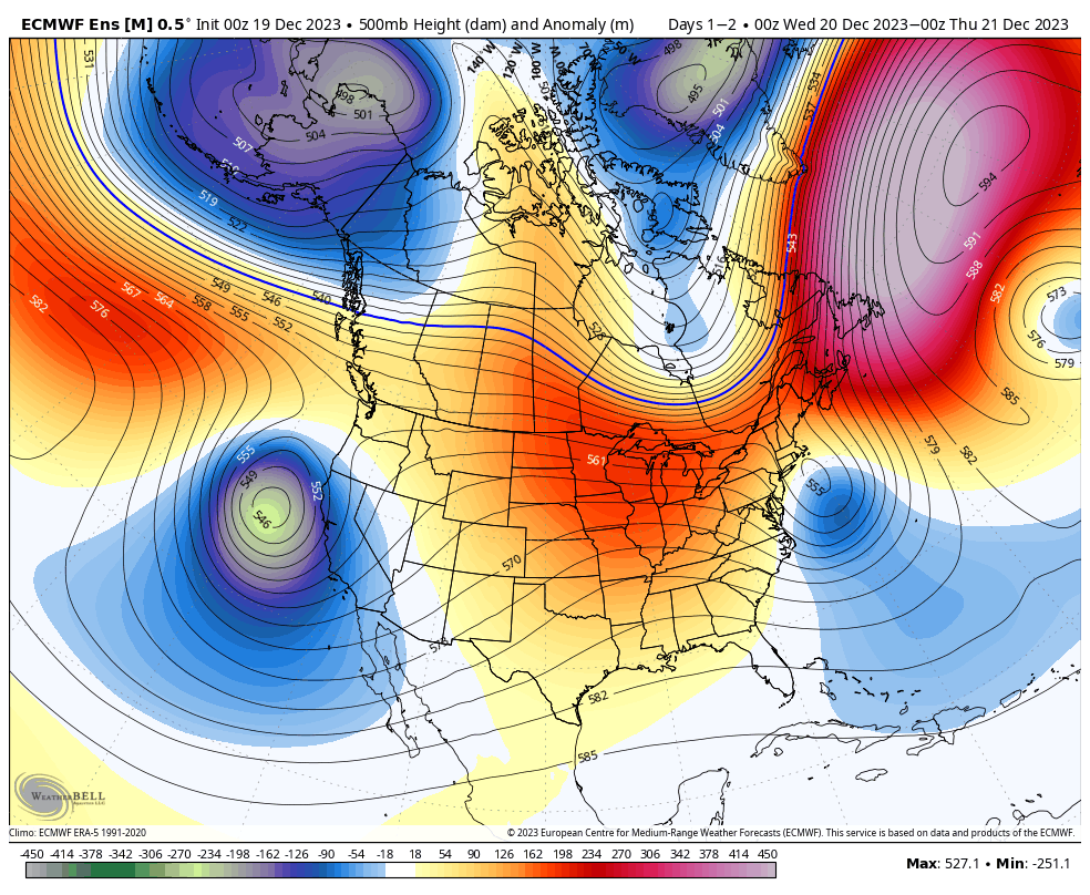
The European Ensemble model showing the weakening and southward movement of the Aleutian Low forecasted over the next few days, leading to lower heights (blue) and colder temps across the Northeast. WeatherBell
With changes in these key variables, a -EPO takes hold as January moves in.
Textbook example of a -EPO, with ridging over Alaska and cool temps for the Northeast. World Climate Service
A -EPO is one of a few important oscillations that can bring cold and snowy weather to the eastern US. There is also the North Atlantic Oscillation (NAO), where a negative phase is sought after by snow lovers.
However, the EPO might be the most important. A 2019 study by meteorologist Dr. Simon Lee showed that the Alaskan ridging associated with a -EPO is the most significant contributor to cold outbreaks across the contiguous United States. (To access the study, click here: https://agupubs.onlinelibrary.wiley.com/doi/full/10.1029/2019GL085592)
Many historic Northeast snowstorms of the past have had some form of a -EPO with strong ridging in Alaska. These include the Blizzard of 2016 and the Superstorm of 1993. Not only this, but cold outbreaks like in the winter of 2013-2014 also fall in the correlation.
It's not to say that these storms will repeat themselves next month. We are simply entering a more favorable pattern for below average temperatures in across our region.
With help from a -EPO, along with keeping your fingers crossed, it appears that there might be snow at the end of the tunnel for the Northeast.